I wrote a couple of months back about the power of movies to preserve a record of cities as they used to be. In that post I included various pieces of footage of Melbourne, and one interesting thing was how recognisable the streets remained. There was no mistaking many locations – such as Princes Bridge, Elizabeth Street, and St Kilda Road – in footage as much as a century old. Despite everything that has gone on in the last century, Melbourne in the 1910s remains fundamentally recognisable. But how much can a city change?
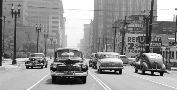
That question was prompted by a video guaranteed to push both my film and planning nerd buttons: 1940s footage of Los Angeles recorded to be back-projection footage for a driving scene in an (unknown) movie project. This came to my attention via The Atlantic and UrbanPhoto blog’s twitter feed, and was originally posted in truly astounding quality by The Internet Archive (here). Below is a YouTube embed, but you can get even better quality on their page.
This footage is of Downtown L.A. and the nearby Bunker Hill district, and it gives some sense of just how profoundly Los Angeles has been transformed. In my previous post I alluded to the remarkable books by John Bengtson that reconstruct silent-film-era Los Angeles from the films of Buster Keaton, Charlie Chaplin, and Harold Lloyd; one thing you get from his work is an idea of just how different a kind of city Los Angeles was in the first part of the twentieth century. This footage reinforces that.
The first thing I did after watching it was to try to find the locations in present day Los Angeles using Google Street View. It’s a difficult task: not only are the majority of the buildings gone, but the redevelopment of downtown L.A. has in many cases fundamentally re-shaped the topography. A commenter on the Atlantic’s page offers the following:
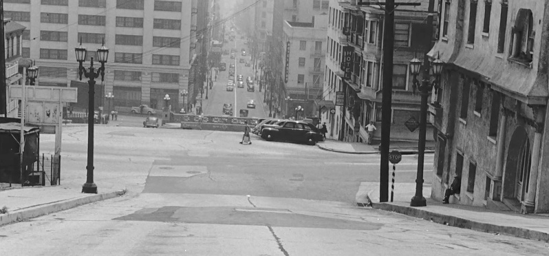
Fascinating! I’m pretty sure the shot starts on 3rd St. looking east at Olive St. and then looking down on where the lower part of 3rd Street goes into the tunnel. The Hotel Astor visible on the right two blocks down is now the Kawada Hotel. Except for a glimpse of City Hall, almost none of the buildings you see for the next couple of blocks are still standing. The route starts by turning south on Grand Ave. to 5th St. As they turn west on 5th, you can catch a glimpse of the Biltmore Hotel, and then along 5th, you see the Central Library. We then turn north on Flower St., which is pretty much unrecognizable now. In the background you can see the amazing Art Deco-style Richfield Tower, where the Arco Towers were later built (which are now the City National Tower and Paul Hastings Tower). We then turn east on 2nd Street and go a block or so before the reel ends
Yet it’s hard to reconcile this with the footage, since the video re-sets several times. One of the clearest moments is the turn from Grand Avenue to 5th, which is at 3:35 in the video and corresponds to this corner in present day L.A.:
Note: these street view embeds may not show up properly on all devices (they don’t work on my iPhone). If they don’t work maybe try another device or browser.
Even more dramatic, though, is the transformation of the scene of the opening shot. The commenter above places this looking down 3rd Street from the corner of Olive Street: if this is right, this is a view that basically no longer exists due to redevelopment. However, they also suggest the building visible a couple of blocks away is now the Kawada Hotel. That’s on the corner of South Hill and Second Streets, meaning that the view would be down the hill on Second Street, from just above Olive Street. So here’s the still from the 1940s again:

Note the point at the centre of the shot where the street disappears into the tunnel, and the rectangular, three-windowed Kawada / Astor hotel building beyond it. Los Angeles here looks a lot like San Francisco.
Now here’s approximately the same view now (as best as it can be established) on Second Street, just below the intersection with Olive Street, but with the shared reference point of the red brick Kawada Hotel building and the drastically re-engineered tunnel entrance in the foreground.
It’s a pretty stunning urban transformation. It isn’t just that low rise buildings constructed to the street have been replaced with parking garages and much larger towers. It’s more than that: the sheer scale of redevelopment has fundamentally erased any trace of the urban form that was there six or seven decades ago. It’s a level of change I would normally associate with a war or natural disaster.
For a bit more of a glimpse of this former L.A., again via the twitter feed of the UrbanPhoto blog, here’s a Ford promotional film that includes footage of Los Angeles in 1917.
Related items
For more commentary on film as a means of preserving a record of built form, see the archives for this tag: film as heritage.